
Blow-Me-Down Bridge
Cornish, Sullivan County, New Hampshire
Last checked 2026-11-01 · Sources · More New Hampshire bridges

At a glance
- Status
- Listed in the state's covered bridge inventory[1]
- Year built
- 1877[1]
- Truss type
- Multiple Kingpost truss, single-span[1]
- Length
- 86' long[1]
- Vehicle access
- Not verified
- Parking
- Not verified
Directions go to the bridge's mapped point, not a confirmed parking area.
About this bridge
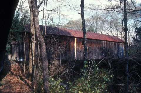
Blow-Me-Down Bridge is a covered bridge in Cornish, Sullivan County, New Hampshire. It appears in the NH Division of Historical Resources covered bridge inventory. The state record gives its construction date as 1877. Its structure is recorded as multiple Kingpost truss, single-span. Wikidata records it as crossing Blow-me-down Brook. It is listed on the National Register of Historic Places (reference 78000220).
Bridge details
- Town
- Cornish[1]
- Location / road
- Mill Road, Cornish[1]
- Year built
- 1877[1]
- Truss type
- Multiple Kingpost truss, single-span[1]
- Length
- 86' long[1]
- Maintained by
- Town of Cornish[1]
- Crosses
- Blow-me-down Brook[2]
- National Register ref.
- 78000220[3]
- Load posting
- Posted for six tons (state inventory)[1]
- NH bridge number
- 23[1]
- World Guide number
- 29-10-10[1]
- Coordinates
- 43.51729, -72.37399[1]
History
Blow-Me-Down Bridge was constructed by James Tasker. The structure was repaired by Milton S. Graton and his son Arnold M. Graton of Graton Associates, Inc., in 1980. The Cornish Historical Society sponsored a reopening ceremony on October 26, 1980, attended by two of Tasker’s descendants, Tasker’s great-grandnephew, Hyland E. Tasker (1917–2009) of Connecticut, and grandnephew, John B. Tasker (1899–1996) of Hillsborough. The bridge was repaired again in 2002 by Richard Thompson of Sunrise Woodworks, LLC of Cornish for a cost of $75,000. The Blow-Me-Down Bridge is listed on the National Register of Historic Places.[1]
Text as published in the NH Division of Historical Resources covered bridge inventory, checked 2026-11-01.
Visiting
We have no official parking, accessibility or opening information for this bridge. Many covered bridges sit on working town roads. Park only where it is legal and safe, respect private property and posted signs, and check town or state notices for closures.
Not verified
We have not found an official source for: Vehicle access, Parking, Accessibility, Opening hours or seasonal closures. We leave these blank rather than guess. Never assume a road means you can drive, park or walk here.
Map
Red dot: this bridge. Green dots: nearest bridges in our list. Distances are straight-line, not driving.
Nearby bridges
- Martins Mill Covered Bridge (Hartland): 1.5 mi straight-line distance, not driving distance
- Cornish-Windsor Bridge (Cornish): 3.1 mi straight-line distance, not driving distance
- Dingleton Hill Bridge (Cornish): 3.7 mi straight-line distance, not driving distance
- Blacksmith Shop Bridge (Cornish): 3.9 mi straight-line distance, not driving distance
- (Willard) Twin Covered Bridge (Hartland): 5.4 mi straight-line distance, not driving distance
Sources
- NH Division of Historical Resources covered bridge inventory: checked 2026-11-01
- Wikidata: checked 2026-11-01
- National Register of Historic Places (NPS), via Wikidata reference number: checked 2026-11-01
- Wikipedia article (background reading; not used for facts on this page)
Spot an error or a closure? Report a correction.