
Mount Orne Bridge
Lancaster, Coos County, New Hampshire
Last checked 2026-11-01 · Sources · More New Hampshire bridges
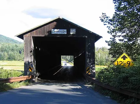

At a glance
- Status
- Listed in the state's covered bridge inventory[1]
- Year built
- 1911[1]
- Truss type
- Howe truss, two-span[1]
- Length
- 266' long[1]
- Vehicle access
- Not verified
- Parking
- Not verified
Directions go to the bridge's mapped point, not a confirmed parking area.
About this bridge
Mount Orne Bridge is a covered bridge in Lancaster, Coos County, New Hampshire. It appears in the NH Division of Historical Resources covered bridge inventory. The state record gives its construction date as 1911. Its structure is recorded as howe truss, two-span. Wikidata records it as crossing Connecticut River. It is listed on the National Register of Historic Places (reference 76000124). It spans the state line and also appears in Vermont's inventory as the Mount Orne Covered Bridge (Lunenburg).
Bridge details
- Town
- Lancaster[1]
- Location / road
- South Lancaster Road, Lancaster, NH/Lunenburg, VT[1]
- Year built
- 1911[1]
- Truss type
- Howe truss, two-span[1]
- Length
- 266' long[1]
- Maintained by
- Towns of Lancaster, N.H. and Lunenburg, VT[1]
- Crosses
- Connecticut River[2]
- National Register ref.
- 76000124[3]
- Load posting
- Posted for six tons (state inventory)[1]
- NH bridge number
- 30[1]
- World Guide number
- 29-04-08[1]
- Coordinates
- 44.46021, -71.65279[1]
History
The first bridge at this site was constructed between 1870 and 1885 to connect the towns of Lancaster and Lunenburg. The owner, Union Bridge Company, operated it as a toll bridge until it was destroyed by a flood in 1905. Ferry service connected the two communities until a new bridge was built in 1911. Each town contributed $2,500. The remaining $1,678 was raised by subscription. The timber for the bridge was precut and assembled at the site. In 1969, a truck loaded with highway salt dropped through the deck and landed on the ice below. The front of the truck hooked on a steel rod in the bridge while rear rested on the ice. The truck was raised, disengaged from the bridge, and lowered to the ice. It was quickly dragged away from the salt weakened area, turned upright and loaded onto a flatbed on the Vermont side of the river. The bridge was closed on July 5, 1983 for twelve weeks to allow rehabilitation by the state of New Hampshire at a cost of $133,000. Funding came from the towns of Lancaster and Lunenburg, the states of New Hampshire and Vermont, and a federal Historic Preservation Fund matching grant from the National Park Service of the U.S. Department of the Interior through the New Hampshire Division of Historical Resources. The rededication of the bridge took place on November 23, 1983. The Mt.Orne Bridge is listed on the National Register of Historic Places.[1]
Text as published in the NH Division of Historical Resources covered bridge inventory, checked 2026-11-01.
Visiting
We have no official parking, accessibility or opening information for this bridge. Many covered bridges sit on working town roads. Park only where it is legal and safe, respect private property and posted signs, and check town or state notices for closures.
Not verified
We have not found an official source for: Vehicle access, Parking, Accessibility, Opening hours or seasonal closures. We leave these blank rather than guess. Never assume a road means you can drive, park or walk here.
Map
Red dot: this bridge. Green dots: nearest bridges in our list. Distances are straight-line, not driving.
Nearby bridges
- Mechanic Street Bridge (Lancaster): 4.7 mi straight-line distance, not driving distance
- Groveton Bridge (Northumberland): 11.7 mi straight-line distance, not driving distance
- Riverwalk Covered Bridge (Littleton) (Littleton): 12.2 mi straight-line distance, not driving distance
- Stark Bridge (Stark): 15.5 mi straight-line distance, not driving distance
- Burrington Covered Bridge (Lyndon): 16.9 mi straight-line distance, not driving distance
Sources
- NH Division of Historical Resources covered bridge inventory: checked 2026-11-01
- Wikidata: checked 2026-11-01
- National Register of Historic Places (NPS), via Wikidata reference number: checked 2026-11-01
- Vermont ANR / VTrans covered bridges map layer: checked 2026-11-01
- Wikipedia article (background reading; not used for facts on this page)
Spot an error or a closure? Report a correction.