
Waterman Covered Bridge
Johnson, Lamoille County, Vermont
Last checked 2026-11-01 · Sources · More Vermont bridges
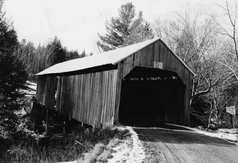

At a glance
- Status
- Lost: collapsed in January 1982[1]
- Year built
- 1868[2]
- Truss type
- Not verified
- Length
- Not verified
- Vehicle access
- Not verified
- Parking
- Not verified
This bridge is recorded as lost. The map point marks its former site.
This page has limited verified data (status is lost or unconfirmed; only 3 sourced facts (needs 4)), so we keep it out of search engines until it is improved.
About this bridge
Waterman Covered Bridge is a covered bridge in Johnson, Lamoille County, Vermont. The Wikidata record gives its construction date as 1868. It is listed on the National Register of Historic Places (reference 74000235). Lost: collapsed in January 1982.
Bridge details
Visiting
We have no official parking, accessibility or opening information for this bridge. Many covered bridges sit on working town roads. Park only where it is legal and safe, respect private property and posted signs, and check town or state notices for closures.
Not verified
We have not found an official source for: Truss type, Length, Crosses, Maintained by, Vehicle access, Parking, Accessibility, Opening hours or seasonal closures. We leave these blank rather than guess. Never assume a road means you can drive, park or walk here.
Map
Red dot: this bridge. Green dots: nearest bridges in our list. Distances are straight-line, not driving.
Nearby bridges
- Power House Covered Bridge (Johnson): 2.0 mi straight-line distance, not driving distance
- Scribner Covered Bridge (Johnson): 2.7 mi straight-line distance, not driving distance
- Red Covered Bridge (Morristown): 6.3 mi straight-line distance, not driving distance
- Village Covered Bridge (Waterville): 7.0 mi straight-line distance, not driving distance
- Poland Covered Bridge (Cambridge): 7.0 mi straight-line distance, not driving distance
Sources
- Wikipedia: Waterman Covered Bridge: checked 2026-11-01
- Wikidata: checked 2026-11-01
- National Register of Historic Places (NPS), via Wikidata reference number: checked 2026-11-01
- Wikipedia article (background reading; not used for facts on this page)
Spot an error or a closure? Report a correction.